Boyanup
Joshua Lake Trail
This path circuit is located within a rehabilitated mineral sand mine on Joshua Creek Rd. The circuit caters for both cyclists and walkers, with high quality flat concrete paths. The Walk features many interpretive panels, and includes several rustic shelters, a bird hide, bench seats, and bench tables. Please note that toilet facilities are currently unavailable at this site.


Munda Biddi Trail
The Munda Biddi is a 900km cycle touring trail between Mundaring and Albany, offering a combination of “off-road / on-road” sections. 8.7kms of the trail passes through Boyanup, utilising Joshua Creek Rd, Armstrong St, and Hurst Rd.
The trail route is marked by distinct directional blue arrows on yellow posts, featuring the Munda Biddi 'message stick' symbol. The yellow posts can be easily seen while riding through the forest and in low light.

Preston River Ramble
The Ramble is a 1.3km walking trail alongside the Preston River, starting at the Lions Park on Bridge St. This trail has recently been upgraded to include a number of interpretive panels, featuring images and input from students at both Boyanup Primary and ChildSide Schools. The trail follows the Preston River, and provides local residents and visitors to the area an opportunity to catch a glimpse of history, observe conservation principles, and engage all five of their senses.


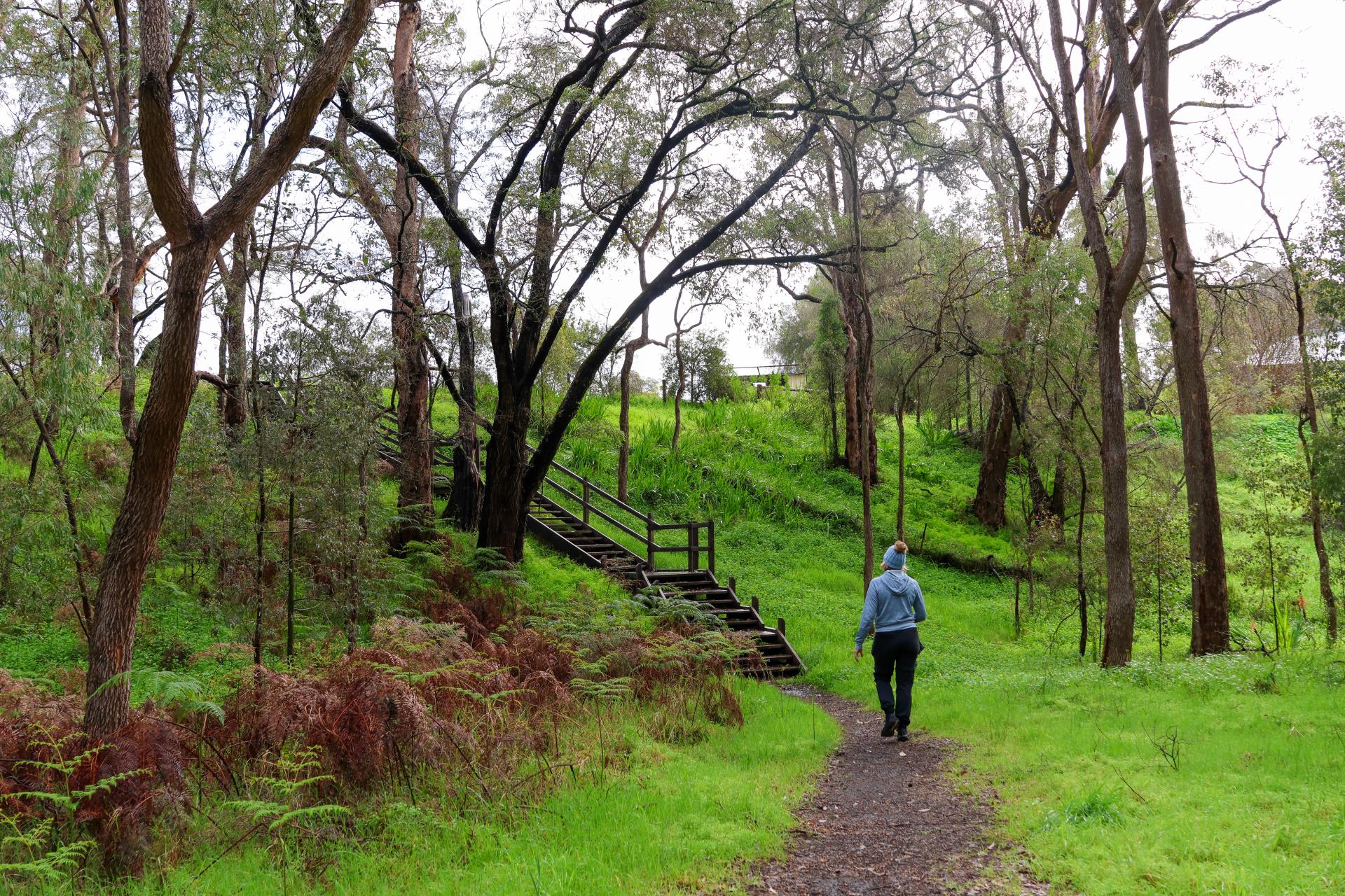
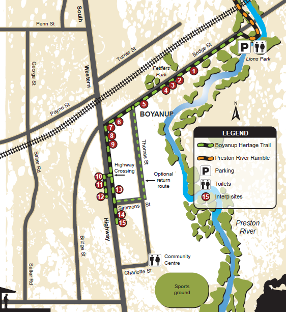
Boyanup Heritage Trail
The Boyanup Heritage Trail also commences in Lions Park and is a pleasant 1100 metre meander through the early settlement history of the town. The southern end point is near the former CWA rooms on South West Highway. The trail follows the south side of Bridge Street before turning down the SW Highway . Trail markers and directional signs clearly mark the designated route. In most cases the panels are visible from some distance away. You can return on the same route or choose to walk back on Thomas Street or Simmons Street for a change of scenery.
15 interpretative panels provide early history and stories from the area. Take the time to enjoy the lovely walk and wander into one of cafes or stores along the way.


Capel
Malaga-Ngwan (Ironstone Gully Falls)
The Ironstone Gully Falls walk trail is an easy 1.5km circular loop in a clockwise direction, starting and finishing in the main day use area. Allow approximately 60 minutes to walk the trail. This particular walk trial is seasonal, with the falls flowing between July and October once the winter rains commence.


Located 17kms south east of Capel on Goodwood Rd, this historic picnic area was reserved in 1903 for use as a recreation area for the Capel River settlers. Although not an official trail, the site is famous for the rich red rock over which a small tributary from the Capel River tumbles. During the wetter months, the stream (which has followed a course through the Jarrah Forest) crosses under Goodwood Rd, gently meanders over a series of rapids before dropping over a nine meter high ledge.


During Spring, the trail features wildflowers, and the area has a remnant jarrah bushland surrounds. The trail is an easy walk comprising of a trail head and eight interpretative panels in a circular clockwise route around the reserve. Bird guides list this site for its potential for sighting raptors, Red-Tailed and Long-Billed Black Cockatoos, and Scarlet Robins.
Toilet facilities are available at this site. Find out more.

Tuart Discovery Trail
Located on Higgins Road, off Stirling Street in Capel, Constructed in 2008/2009
Tuart Forest National Park is a peaceful forest woodland, perfect for a forest walk, picnic or nature watch. It protects the largest remaining pure forest of Tuart trees in the world. It has the tallest and largest specimens of Tuart trees on the Swan Coastal Plain. Some trees are more than 33m high and 10m in girth. Wow!
It’s quite an experience to walk or drive through a whole forest of these majestic trees. Tuarts only grow on coastal limestone, 200km on either side of Perth. And nowhere else!
Tuart forests were once abundant. They were open, with good visibility and tall grassland carpeted the forest floor. Aboriginal people used this grassland to shelter and hunt wildlife.
There’s lots to see here. In spring the park is a riot of colour as wildflowers burst into bloom. In wetter months look out for the many types of fungi, some have yet to be named! All year-round bird spotters will love the waterbirds and other species.
The forest is home to WA's largest remaining wild population of the endangered western ringtail possum. Explore the Possum Night Spotlighting Trail. Follow the reflective trail markers and use your torch. You could be lucky and spot nocturnal residents including the brush-tailed phascogale, bush rat, kangaroo, quenda, and at least 11 species of birds of prey and nocturnal birds. That’s worth staying awake for!


Dalyellup
Tuart Walk
The Tuart Walk is located in the Tuart Forest between Dalyellup (Shire of Capel) and Usher (City of Bunbury). The trail is 1.27kms of high quality, flat asphalt path running between Maidment Parade in Dalyellup, and Ocean Drive in Usher. The Walk caters for a wide section of the Community, including walkers, cyclists, skaters, and parents with prams. The trail features 2 interpretive shelters at either end, as well as numerous interpretive panels throughout the Walk.


Lakes Walk
The Dalyellup Lakes Walk is a quality concrete path, circuiting the main lake in the urban area located on Maidment Parade. This trail features an 80m timber boardwalk as well as a large viewing shelter that extends over the lake. Interpretive panels featuring local wildlife are displayed along the trail.


Bushland Walk
The Dalyellup Bushland Path is a 1.27km, high quality, flat concrete path through linear open space within the Dalyellup urban area. This trail extends from the junction of Dalyellup Blvd and Wonil Cres to the junction of Maidment Parade and Maiden Rd. The path takes you through a section of the Tuart Forest, through well-developed picnic areas, and features 10 interpretive panels about local wildlife. Other outstanding features of this trail include well-manicured lawn areas, playground equipment, bench seats, shelters, and lighting. This trail also has connecting pathways at Wonil Cres and Maidment Parade.
Gelorup
Nature Trail


The Gelorup Nature Trail is situated along the 5 Mile Brook in Gelorup.
The trail has upgraded 1km of a pre-existing fire break on the north side of the Brook from Sheoak Park on Bussell Hwy to the Community Centre on Hasties Road.
The trail, due to its location has improved connectivity, and provided environmental, physical and social benefits to the community of Gelorup.